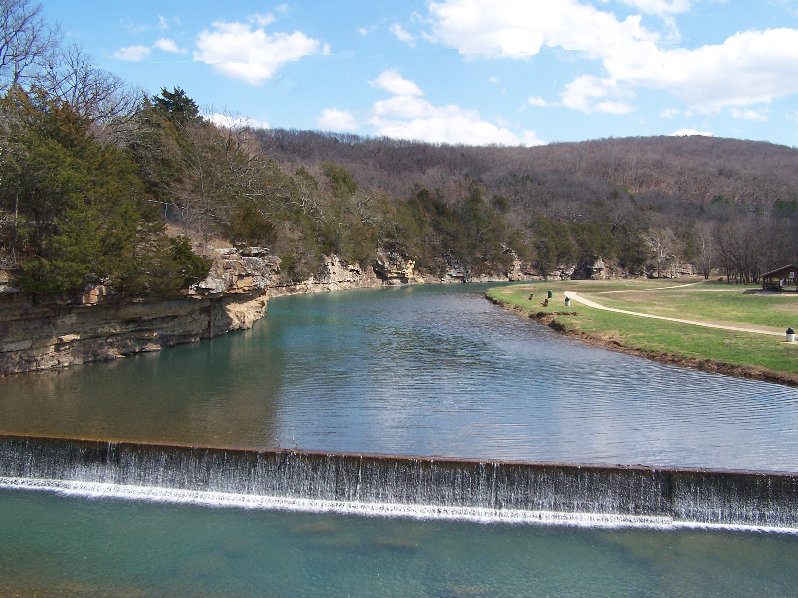
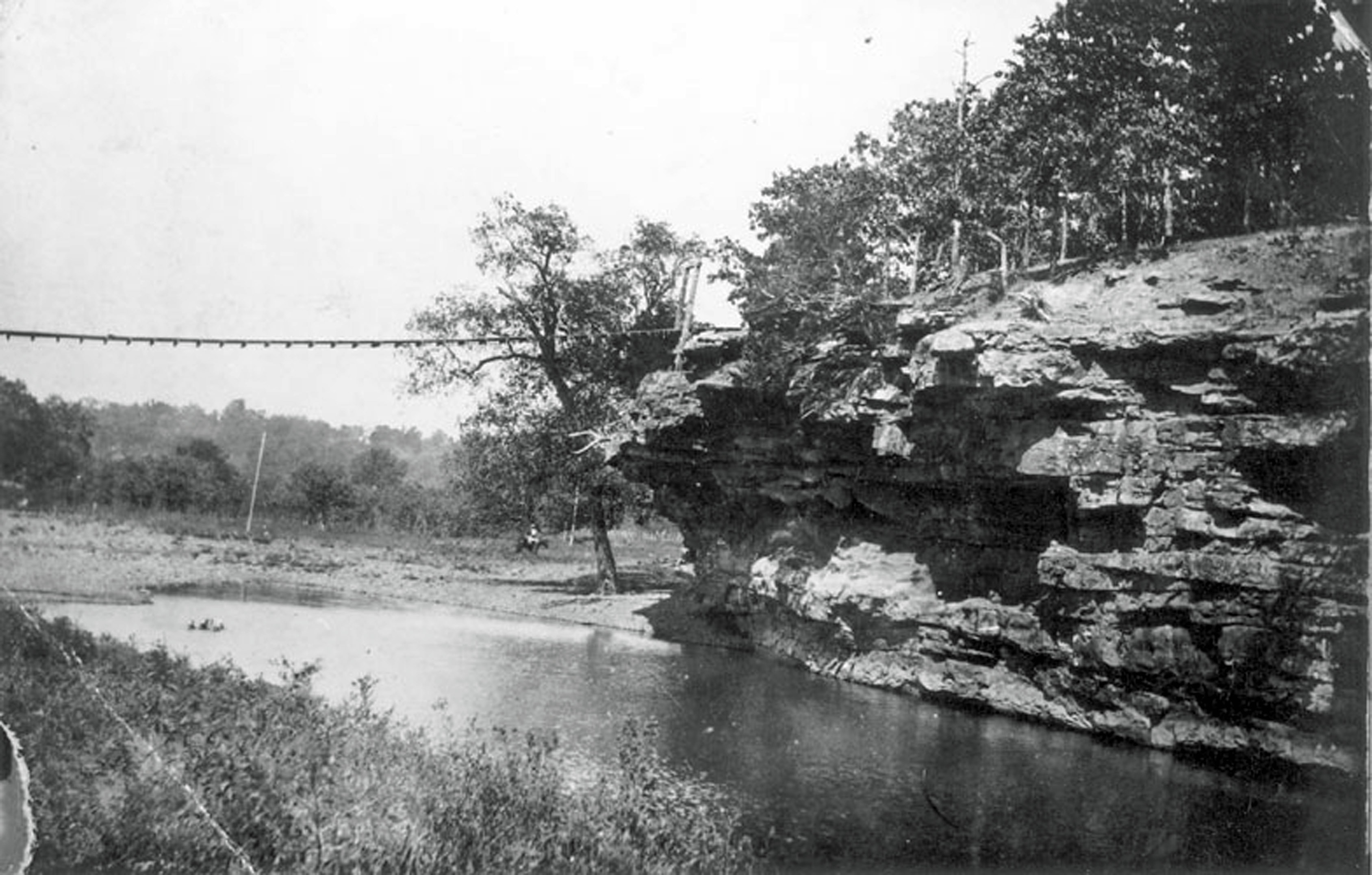
Riverside Park, West Fork. Perfect display of how the river has shaped the land, creating high bluffs and rich bottom land.
I moved into the West Fork Valley in 1973. I had no previous experience here except, as a child, one train ride from Fort Smith to Fayetteville circa 1952 and then passing back and forth from Fort Smith to Fayetteville during the 1950s in our 1949 Chevy (and later our 1954 Chevy). Driving Highway 71 in those days provoked high tension whether we had to pull over to wait out a driving rainstorm or creep along due to impenetrable fog or shudder as big trucks zoomed past.
Mount Gayler provoked an outcry from me and my younger sister—could we stop and have pie at Burns Gables? Could we ride the train? Only one time that I remember did the journey involve stopping for a train ride, a thrilling dash along the tracks circling the pond, wind in my hair, grinning as the high-pitched whistle blew. Another time we sat around a table at Burns Gables to savor a slab of delicious pecan pie.
The landscape of high mountains and sheer cliffs made its mark in my memory. For years my amateur drawings portrayed hills of the same height marching off into the distance in ever faded color. I never understood why it seemed mountains should look that way until, as an adult, I took another look at the profile of the Boston Mountains framing the West Fork valley.
Passing through West Fork on our way north marked the last hurdle before finally reaching Fayetteville, but the only thing that lodged in my memory about the place was the rock “tourist court” along the highway. Then the green-and-white rotating light flashed through the sky at the Fayetteville airport, a magical sight in fog or rain. In those days on that two-lane narrow highway, the trip took nearly three hours.
Imagine my surprise when, in middle age, I discovered that I had ancestors buried at Brentwood and Woolsey! After the Civil War, my dad’s grandfather, Charles McDonald Pitts, moved from Johnson County, Arkansas, to the Brentwood area along with his mother Elizabeth and several brothers and their families. Charles’ mother and his first wife Easter (Parker) and newborn daughter Tennessee are buried at Brentwood as well as a young niece Eliza. Two brothers and some of their children are buried at Woolsey. Charles would remarry there, a local girl named Linnie Mae Rose who became my great-grandmother. The Pitts family moved away by 1900 to take up residence in the western part of the county.
Now, after nearly fifty years of living here, I can almost claim to be an old timer. But fifty years is nothing compared to the two hundred years of family heritage a few of the valley’s residents can claim. I wanted to know who came here first, who built these towns, what it was like to carve out a living in this rugged land. So I started digging.
The West Fork Valley, my new release, is what I found, a history of the watershed of the West Fork of White River, its natural wonders, its past, its people through 1900. It’s my great pleasure to announce this book to the world!
Visit the book page on this site for more information and purchase link.
A few days ago I headed out to explore a road I’d never been down before. It’s less than fifteen minutes from where I live and in my current work-in-progress on the history of the West Fork valley, the road is mentioned often. I thought I should see it.
I was not prepared for what I found there.
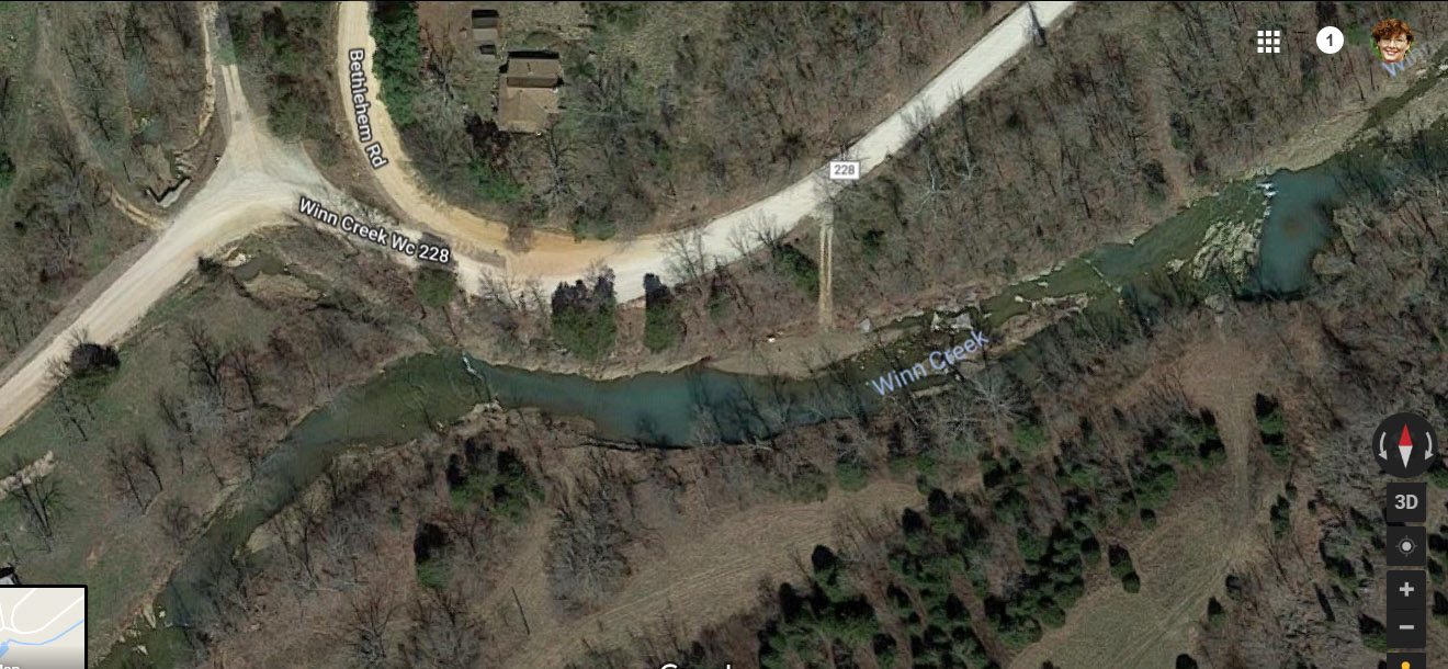
Winn Creek Road. Named after the creek and Zadock Winn, a man who drowned there back in the early days of settlement. Other Winns established homesteads up that valley, too, and maybe the road took that name before Zadock drowned back in 1852. The road veers off southwest from Woolsey Road south of West Fork amid wide flat pastures framed on either side by steep, thickly-wooded hillsides.
You know you’re getting to the good part when you see the “Pavement Ends” sign. The road narrows. You slow down as tires hit the gravel and a cloud of dust rises behind you. The valley attenuates to its essential elements and tree canopy encloses the roadway in welcome shade.
To the right, the hillside rises sharply, its massive rock outcroppings mostly hidden in dense undergrowth and hardwood forest. I imagine how it must have looked to the first man to blaze this path, hacking his way through brambles and vines. I imagine how he eagerly awaited the next curve of the creek as it curled through the 30-foot deep ravine to the left, perhaps thirsty, perhaps eager to splash water on his sweaty neck.
Creeks were the roads before roads, paths cleared by regular torrents where in times of low water, man or beast could walk without fear of ambush by tick or cougar. Infinite generations of rocks large and small line the creek bottom. Pale brown, gray, occasionally black where the roaring water has undercut shale, limestone and sandstone claim the greater share of the lithic congregation. I pass a few houses, some buried on deeply wooded hillsides with “No Trespassing” signs at the driveway, others laid out alongside barns and white graveled drives.
The valley and its waterway curl under the dominating rise of these northern slopes of the Boston Mountains. Here and there ancient landslides or silted bends form little meadows suitable for a house, a garden, even pasture. I drive along watching the land slowly rise as I pass further south. I think of pioneers who claimed these places as their own, the long process of clearing fields to plant their wheat, corn, oats, cotton, and tobacco. I think of their log cabins, the children they raised, perhaps descendants living here still.
I’m immersed in the past when travel through places that required heavy wagons pulled by mules or a faithful horse to pick its way across the rugged land. I think of the millennia before white men, when Natives crept through the underbrush watching buffalo herds graze. I think of the millions of years it has taken this tiny place on our planet to form, primeval seas that covered the land then receded, the rush of glacial melt carving its way through countless layers of primordial continent with its fossils of all that came before.
Finally the road and creek bed approach the same level. I could stop, walk past a broken down fence line, and wade. I could sit and watch the water sparkle in sunlight as it rushes along its path.
I round a last curve and stop mid-breath. My heart leaps into my throat.
A surreal scene spreads across the narrow valley. My mouth falls open in shock. I’m instantly transported to a science fiction world. It’s almost more than I can take in.
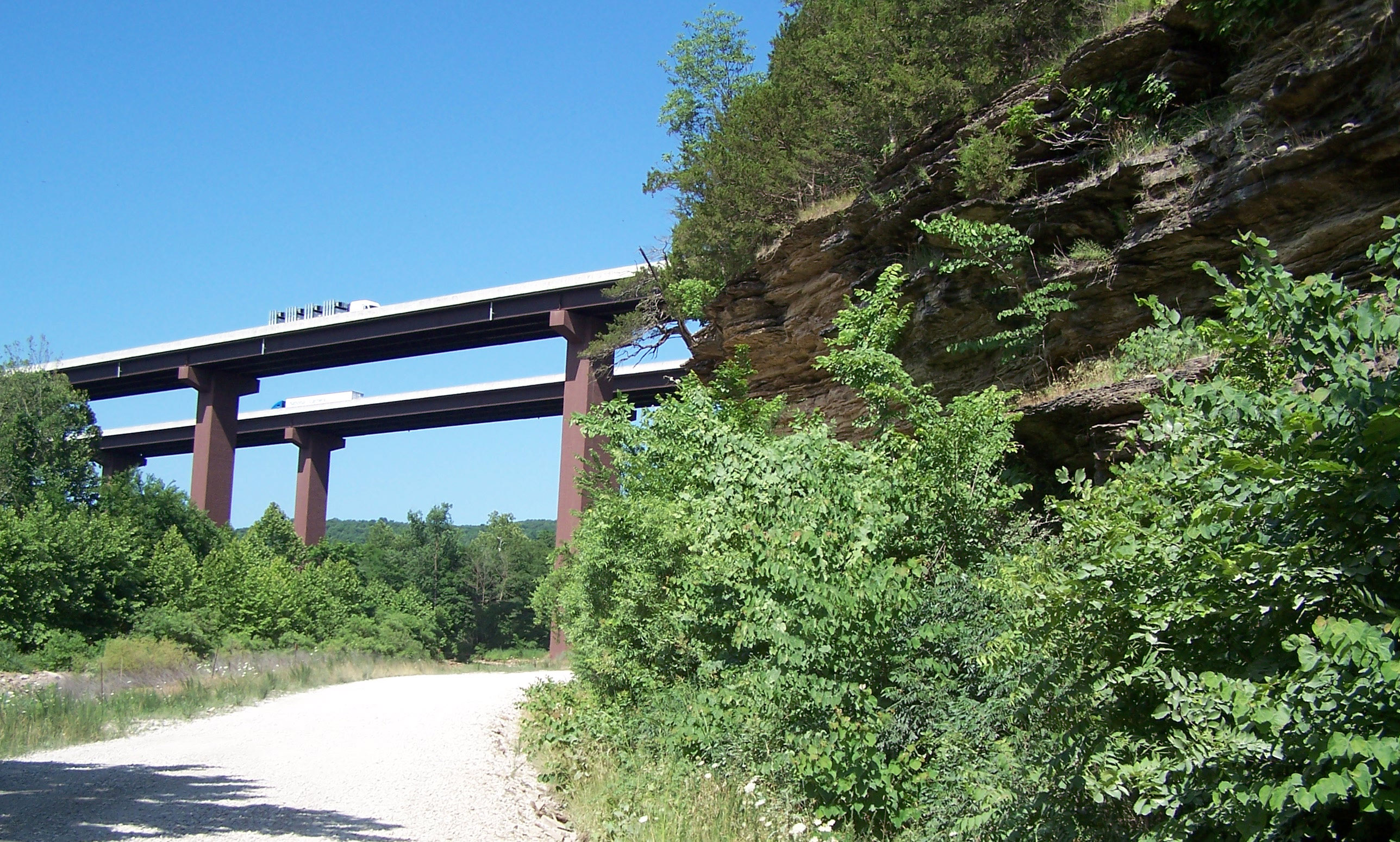
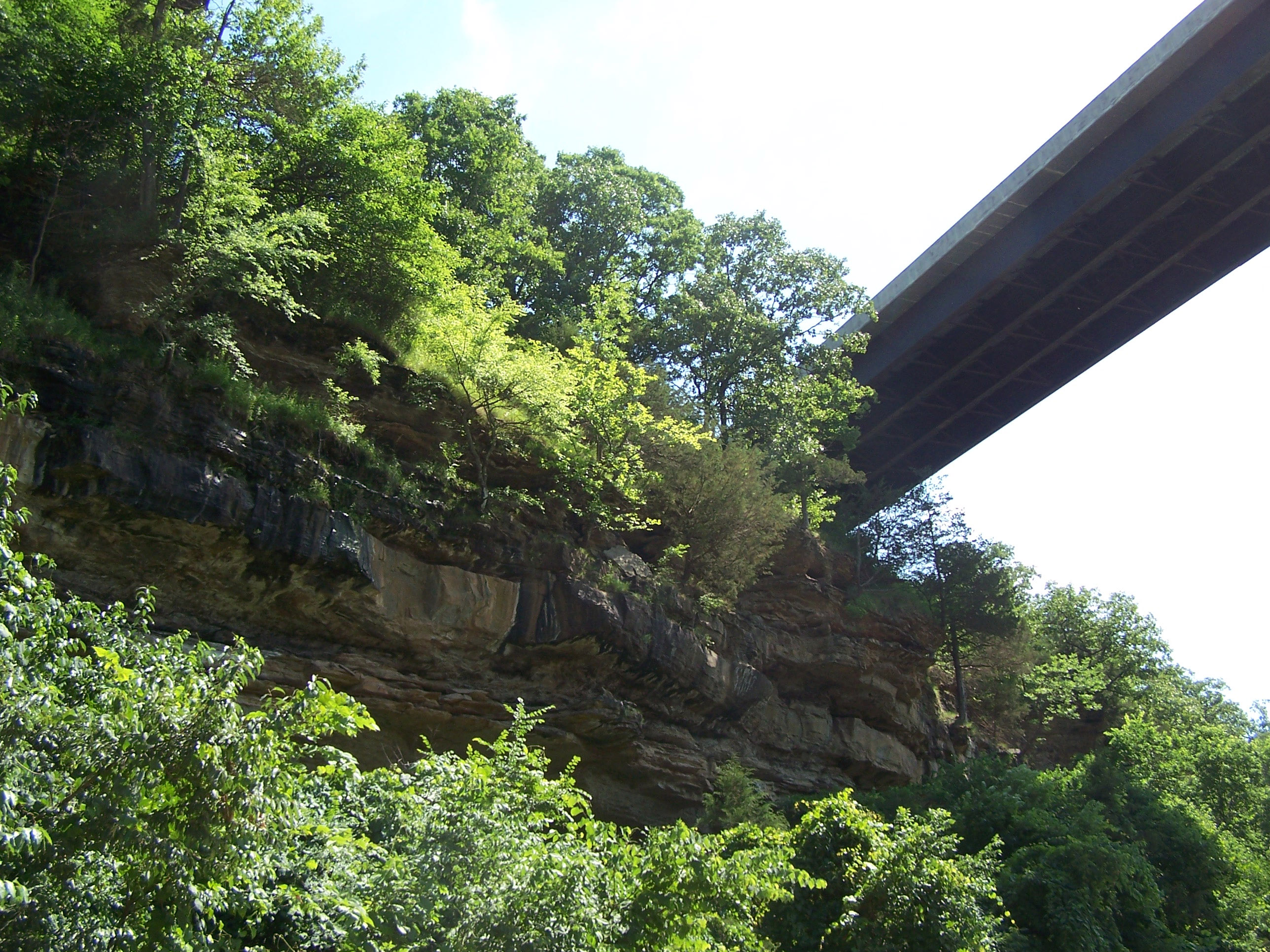
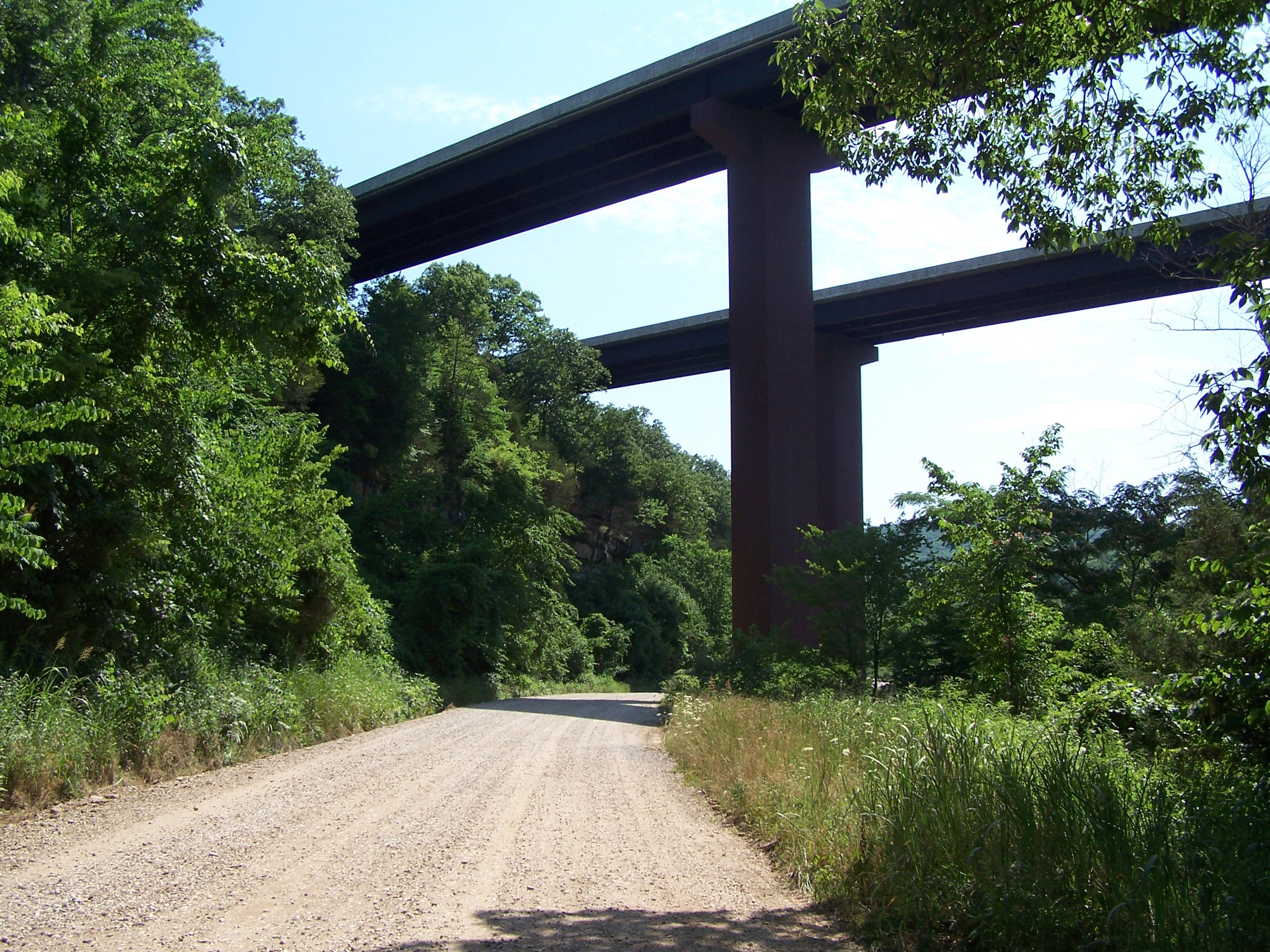
There, straddling the stream and rising so high I must lean forward to see the top, are massive square steel pillars that hold up Interstate 49. The juxtaposition of the interstate and its structural supports against the backdrop of this venerable wild landscape is almost too much to absorb.
I stop, take pictures, try to come to terms with this bizarre reality. I examine the way the highway engineers planned to use the upper canyon wall as a launching pad for the roadway to fly across this valley. I study the exposed layers of earth and stone cut over countless eons by this now-trivial stream, laid bare as if pages of a book waiting to be read.
Not so trivial, even now, it seems. Evidence of raging flood mark the edge of the roadway, grass twisted and brown with silt, knots of weed tangled in fences. I think of Zadock Winn who believed he could cross even though the water foamed and seethed in its torrent. I thought of how, in all things, Nature will always win.
She will win here, too. For now, traffic clatters and roars far above my head, the steady drumming of tires, the regular lub-dub lub-dub as one after another vehicle crosses each section. Some bracing rattles more loudly than others, perhaps already loosening from its original moorings. There is no peace in this valley.
I drive on. Another quarter mile up the road, the creek takes a ninety-degree bend, providing me the fullest view of its intrinsic beauty.
I peer down from the road where it hugs the hillside forty feet above the water. This is the widest point of its course, ornamented in sparkling ridges as layer upon layer of rock gradually step down through the curve. I can almost hear children laughing as they splash and play in the shallow cool water.
Ahead, if I ventured another three miles or so, I’d arrive at Highway 74 where a left turn would take me to Winslow or a right turn would drop me into the wonderland of Devil’s Den State Park. I turn around and go back the way I came.
I drive home slowly, jarred from my normal frame of mind. The experience of that creek and its valley remains an arresting memory I won’t soon forget. It compares with the best stories I’ve seen or read where astonishing realities intersect with the commonplace. The interstate and its undergirding simply do not belong in that landscape.
Yet I’m twenty plus years past any of this being new. Surely the people who lived here during construction grew familiar with the mind-boggling scale of the interstate’s design. Surely the workers laboring day after day through the pouring of concrete and operation of massive cranes to erect these towers saw their labor as being rooted in the ground. It is rooted in the ground. No doubt the foundations for these support towers are driven deep into the strata far below the creek bed.
I wonder how long it will stand, this high-flying roadway built to accommodate a life lived too fast for contemplation of creek bottoms and tumbled rocks. How many decades will these pillars remain? I imagine a future time when only the towers still stand, the path for vehicles long since rusted and crumbled by the forces of weather, traffic, and time. How much of the concrete will fall to this scenic valley? What will it look like here in a hundred years, a mere blink in geologic time?
I’m disappointed in my words and even the photographs to adequately describe my visceral experience of this location. It’s worth the drive to put yourself there, to stand staring up at the work of man while surrounded by the work of Nature. Questions of time, space, and existence arise spontaneously. Of our place in the continuum, of what the future might hold.
Between Winslow and Mt. Gayler, across from Grandma’s Cafe
With the opening of Interstate 49, old Highway 71 through northwest Arkansas has lost most of its traffic. Formerly thriving businesses like the Smokehouse Restaurant near Mt. Gayler have folded up and slipped away in the night. Towns along this formerly packed thoroughfare have suffered losses as well, especially enterprises that depended on highway traffic as much as local customers to keep the black ink on their bottom lines.
Soon after the new four-lane highway opened with its easier grades, straighter curves, and swooping (terrifying) bridges high above the mere mortals below, state and regional officials began marketing the old highway as the “scenic” route. And it is, without doubt, scenic. Crossing the Boston Mountains with their sheer drop-offs and stunning vistas never fails to inspire.
Main Street, Winslow
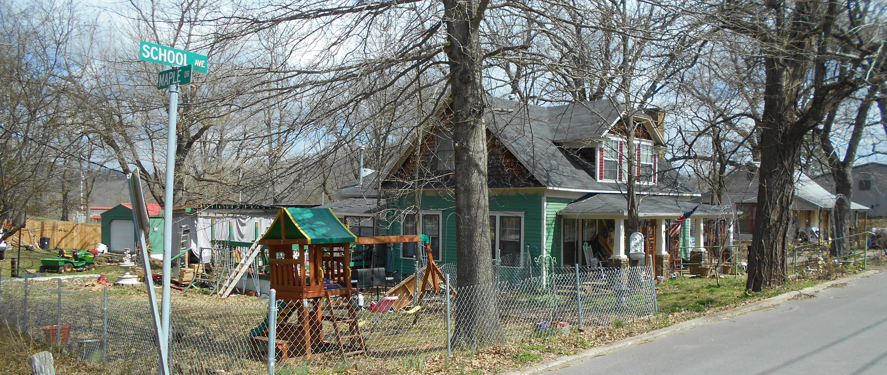
Yet now more than ever, the underbelly of the Ozarks blossoms into view. Not so scenic are places where the property owners have lost the fight with their ‘stuff.’ Mounds of trash, some of it looking as though it was simply tossed out the door, litter their places of habitation. Old vehicles and various implements once used in the pursuit of livelihood sit haphazardly around the place. Cobbled-together homes make creative use of plastic sheeting and various and sundry bits of construction material.
Winslow across from new Dollar Store
These places have become a regular irritant to some locals, one of whom took these photos and sent them to me after I said I’d write a blog post about it. Locals like us have long since accepted the fact that some folks either can’t or won’t make the effort to present a respectable front to the world. There’s no shortage of such scenarios along just about any dirt road you might care to drive. But along the highway, a highway advertised as “scenic,” these places paint the entire region with a dismal color of decay and poverty.
Maybe the world expects to see evidence of destitution and apathy in the Ozarks. After all, ever since the publication of the “Arkansas Traveler” song in 1840, this region has suffered the disdain of many for its slovenly ways. Even now the more ‘civilized’ regions on either coast consider all of the hill states to suffer similar inability to come up to snuff–not that they don’t have their own ghettos.
Across from Silver Leaf campgrounds, Winslow
Unfortunately, time and again those stereotypes are borne out in real life. Homeowners barely scrape by, making do with what they’ve got, saving every scrap in case it might be needed. Or they’re renters unwilling and/or unable to improve on a place they’ll never own and whose owner can’t be bothered to make needed repairs. Or people whose lives have run over them with injuries or job loss or a litany of emotional defeats that leave them incapable of trying to make things better.
Brentwood
There are no zoning laws in Washington County that require people to clean up junk piles or dead vehicles or really much of anything. It wasn’t until the last couple of decades that an ordinance was passed requiring that electrical wiring standards be met in rural housing and that came about only after children died in a fire caused by poor wiring. Laws forbidding the surface disposal of sewage passed only a short time before that, and even now a properly-built outhouse remains legal despite the karst geology that allows pollutants to rush right through fractured layers of rock and loose soil to percolate into groundwater that surfaces as springs and streams. All of it, including discharge from septic tanks, ends up in Beaver Lake which supplies drinking water for the entire region.
It wasn’t until the late 1980s that landfills were required to monitor discharge and place liners under the trash. Some efforts have resulted in the cleanup of junkyards where vehicles in various stages of decay leak oil, gasoline, and various other noxious fluids into the waterways. Other efforts attempt to stop residents from openly burning trash, a practice that releases toxic chemicals like dioxin, furans, and dangerous particulate into the air we all breathe.
But there’s a mindset lurking in the minds of our people, that this is their place and they can damn well do what they please.
She speaks for us all, confessing to the check-out clerk with an excited laugh that if it’s going to ice, she’d better get ready. Milk, bread, chocolate bars, corn meal—her choices are different only in detail from the rest of us standing in line, in a store so jam-packed that even the stock boys work up front wearing jackets over their aprons and sacking supplies that will keep us secure when the weather moves in. Cars and trucks crowd the parking lot, some left running with the plumes of their exhaust whipping sideways in the freezing wind.
Men wait holding meat, bananas, coffee, restless in insulated tan coveralls with the legs unzipped over their heavy clay-soiled boots, their hair packed down against their heads where knit hats had been. Uneasy in a role usually filled by their wives, they joke, catch up with old acquaintances who also stand in line, promising to call soon, men not accustomed to being off work at one p.m., hurrying home to family before the sleet starts.
The cold comes first, thirty-five degrees when I started to town in the morning, twenty two when I return home, fifteen by three. Wind rocks the great oaks side to side, piling stiff dead leaves in new arrangements at the corner of the woodpile, at the steps. Twelve degrees at dusk, the clouded sky pale pink and white, the countryside settling into frozen night.
More wood on the fire at midnight and two a.m. I shiver by the fire. The house creaks.
Five-thirty a.m. by my bedside clock, the tick-tick of sleet against the windows wakes me. I indulge in another hour of fitful sleep, comforted by heavy quilts and cats at my feet. Plans of all I could do race through my dreams, the albums not finished, correspondence neglected, the watercolors so long set aside. Roads coated in ice mean a day without visitors, a day at home tending the fire, tending myself.
Dressed in sweaters not worn for five years, in long socks and with no regard to appearance, I sip hot tea at the window. Only a small shift in the light signals dawn, lifting the dark blue cast of the air to a lighter shade. Barely visible deer move slowly through the woods, pawing at the ice-coated duff. Tiny crystalline flakes of snow filter into the sleet, thickening the white of the downfall, obscuring trees at the fence line.
Four degrees.
I build a fire in the wood-burning cook stove. A kettle of water with cinnamon oil steams while I craft my list of things to do, tasks that seem too petty or cumbersome for normal days when open roads and obligations burden the hours. I simmer apricots with honey and ginger and fry half-moon pies, edges evenly crimped with tender fork lines. I sketch scenes, the road to my house, the long-familiar contoured hills, and let watercolor swirl on the heavy paper, a skyscape of gray and blue, fields tan, oaks silhouetted black.
Freshly washed clothes hang by the blistering stove whose greedy heat soon pulls out all moisture. With satisfying frugality, a pot of vegetable soup thick with garlic and a pan of beans decorate the stove top, cornbread in the small sooty oven. Every few hours I rush out for more wood, lingering coatless in the sharp scent of cold and wood smoke, large flakes of snow tumbling down into my hair, resting on my eyelashes.
The winters have not been accommodating in recent years, failing first with abbreviated snows, then disappointing even in temperature. In the onslaught of global warming, the Ozark hills have increasingly remained accessible in deepest January, when a few decades earlier our steep, curving roadways had been reliably impassible for at least two arctic weeks of the year. We grew up expecting that at times chosen by Nature, no one would venture out. The guy with the local wrecker service would make enough money to last until June.
In this mid-South clime, we don’t get winter enough to justify the county’s expense for snow plows. It suits us better to schedule school years with extra days for snow. It pleases us to find ourselves unexpectedly confined to the house discovering long lost treasures at the back of the closet, reading magazines, standing at the window as midday lightens the sky to a shade barely more luminous than the snow lying thick on the ground.
Lately, with the warming climate, there has been little winter at all. Days have run together, no time to reflect, restore, sleep in the afternoon. We long for the cold, the ice, roads we could not drive, jobs we could not attend.
Welcome then this celebration of ancient instincts to stay in the cave, content with the provisions we have hoarded, the firewood we have stacked near the door, wrapped in the warmth we have made. Embrace this triumph of man over the elements, a proof of our adequacy in a time when little else seems so clear.
This piece is excerpted from my collection of essays, I Met a Goat on the Road–and other stories of life on this hill. Published 2013
Great gifts abound at your local bookstore. In Fayetteville, Arkansas, that means Nightbird Books on Dickson Street where you’ll find all my books on local history.
Check out Murder in the County: 50 True Stories of the Old West, a collection of murder stories from the 1800s here in this county.
Less expensive but just as intriguing, The Violent End of the Gilliland Boys chronicles the amazing journey of one pioneer family, also a local story.
Don’t live in Northwest Arkansas? Simple — check out all my books at Amazon.com
A visiting guinea? A ‘possum in the dining room? What strange and wondrous occurrences can one expect while living on an Ozark mountaintop for over forty years?
These lyrical adventure stories feature chickens, raccoons, bugs, dogs, cats, and natural critters of this woodland home. Throw in a few neighbors who shoot copperheads or remodel the dirt road. Ponder the passage of time through a philosophical lens of wonder and delight. The seasons bring summer heat, winter snow, pouring rain, the power of fire. Lessons learned, questions posed–who has lived and died on this land? What is our responsibility to this place, its creatures, each other?
1972. A Yankee learns the Ozarks way and lives to tell his tales. Now almost a native, Denny fondly reminisces about the people and places of his adopted home.
Denny Luke is an adventurer. During his years as a Navy man, he built hot rods with money he made with shipboard loansharking. He returned to his native Ohio where he soon tired of the mechanic’s life. Computers had just started to break the surface in 1966, the perfect attraction to a young man with a sharp mind and plenty of ambition.
Hot cars and Enduro racing occupied Denny’s next few years as he helped usher in the computer age in Minneapolis. But another adventure awaited when in 1970 he fell in with a bunch of hippies. By 1972, he had found his way to the Ozarks.
An avid photographer and storyteller, Denny shares the adventures of his life as he recalls the outrageous backwoods tales and colorful characters who populate the southern fringe of Washington County in Northwest Arkansas.
In the completion of my recent book, Murder in the County: 50 True Stories of the Old West, I discovered that three of the fifty murders profiled there were committed by members of the same family! Intrigued, I researched more about these folks and the result is now published under the title The Violent End of the Gilliland Boys. Fascinating and shocking, this story features more twists and turns than an Ozarks dirt road.
Christmas Day horse races 1872, Middle Fork Valley. Young Bud Gilliland waits, eager for another chance at his neighbor Newton Jones. Only this time, after two years of sparring, Newton gallops up in a cloud of dust, aims his Spencer rifle, and sends Bud to a well-earned grave.
The death of Bud surely grieved his father. But before the curtains closed on these descendants of J. C. and Rebecca Gilliland in 1891, two other sons and a grandson would die a violent death while yet another grandson served hard time for murder.
What was it about the Gillilands?
This recounting of the family tracks their ancestry, their pioneer years on untamed land, and the hard work that made them one of the wealthiest families in Washington County, Arkansas. A fascinating tale of brash ego, brave gallantry, and plain old bad luck.
Paperback now available for only $9.95 at. Don’t miss it!
Murder in the County: 50 True Stories of the Old West
Contrary to popular notion, Arkansas was part of the Old West along with Texas and the rest of those more familiar dusty southwestern places. Its western border joined up with the Indian Nations where many a weary marshal rode out with his bedroll and pistol carrying writs from the U. S. District Court at Fort Smith in a search for a steady stream of men rustling livestock, stealing horses, selling whiskey, or running from the law.
From its earliest days, Washington County, Arkansas, experienced some of the worst the Old West had to offer. At unexpected moments, county settlers faced their fellow man in acts of fatal violence. These murderous events not only ended hopeful lives but also forever changed those who survived them. Not to say that the murders in the county all stemmed from conflict along its western border—plenty of blood spilled within its communities and homesteads.
The fifty chapters of this collection each focus on one violent incident. Through family histories, legal records, and newspaper accounts, the long-dead actors tell their shocking stories of rage, grief, retaliation, and despair.
Two hundred years ago, in 1819, the first white man known to explore this area, Frank Pierce, traveled up the White River from the Mississippi and across the northern part of the state before arriving at the west fork of the river and stumbling into this valley. Frank had long since run through his supplies and on this day had worked up a powerful hunger. Thinking of fresh meat over an open fire, he had a buffalo in his gun sights when he noticed a band of Natives also stalking the herd. Although the Osage and Quapaw had historically occupied these lands, right after the Louisiana Purchase, the U. S. government had begun moving Cherokee and other eastern tribes into the region. The Natives ole Frank saw that day were probably Cherokee. He gently released the hammer of his gun and slipped back into the dense undergrowth to spend the night hungry in the shelter of a large tree.
But he lived to tell the tale.
Nine years later in 1828, Frank was among the first settlers to arrive with the official opening of Arkansas Territory. Whether receiving bounty land for service in the Indians Wars or the War of 1812, settlers rushing to stake their claim on a forty acre parcel found springs and lush vegetation in these flat hilltops and river valleys. Wildlife including buffalo, cougar, elk, bear and wolf all roamed this valley. Alongside the forest with trees as big as four feet in diameter, there were wide stretches of tall prairie grass in a thriving ecosystem.
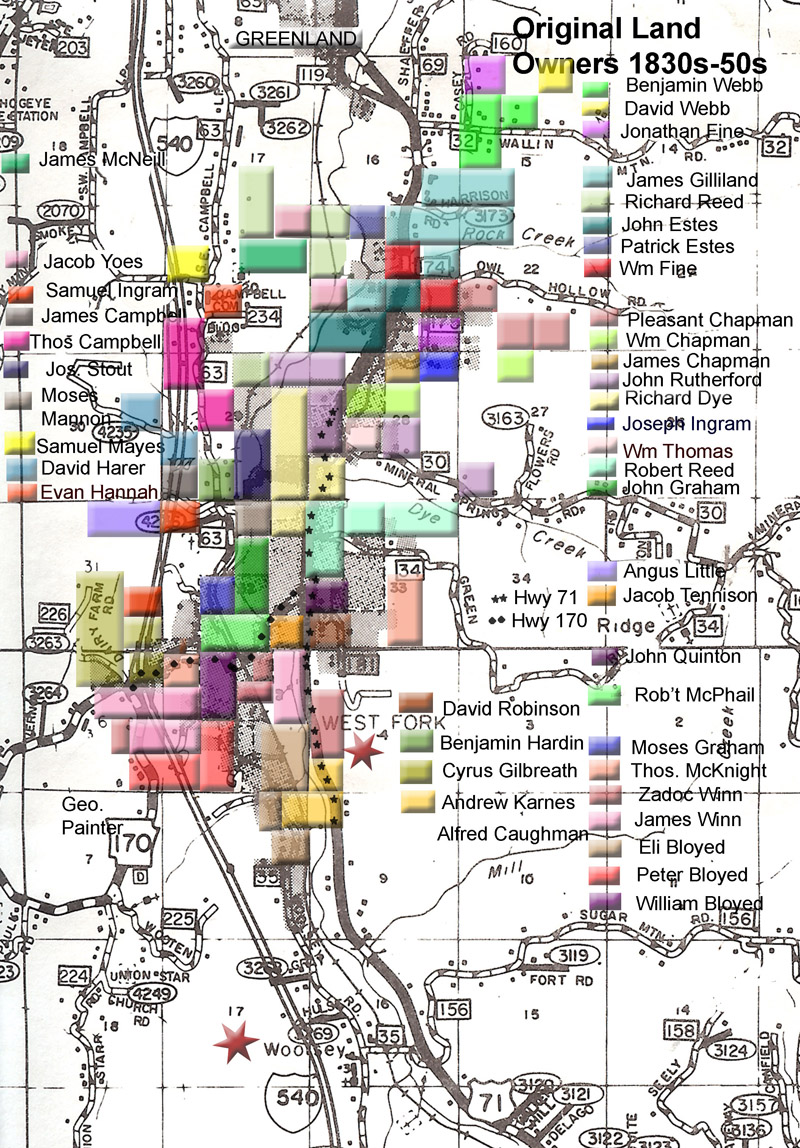
Throughout the first fifty years of county history, ‘West Fork’ wasn’t West Fork the town as we know it. The term ‘west fork’ referred to the west fork of White River and West Fork Township. Persons living along this long river valley from Winslow to Greenland were said to be from ‘West Fork,’ so this confuses some of the history. Any records before 1885 that refer to West Fork are not about the current town of West Fork.
As early as 1831, settlers organized a church in the valley, considered to be the oldest organization of a Christian church in Washington County. Church records from 1837 describe meeting under and elm tree with charter members Stephen Strickland and wife, Richard “Dick” Dye, Eli Bloyed and wife, C. G. Gilbreath and wife, Greene W. Sherry and wife, and fifteen more couples. By 1855, followers of the Cumberland Presbyterian Church were meeting at Dye School House on land owned by Richard Dye. Local residents are probably familiar with his name because of the creek named after him—it crosses Highway 71 beside Dye Creek Road.[1]
Mills served a critical function for early residents who needed their corn and wheat ground into meal and flour and their logs sawn for lumber. Census records suggest a mill serving the south county was first located just north of Brentwood on the properties of William “Billie” Knott and Eleazer Pelphrey, the two men occupied as of the 1850 census as millwright and miller, respectively. Their properties at the SE ¼ of the SW ¼ of Section 23, Township 14, Range 30 West (Knott) and the West ½ of the SE ¼ of the same section (Pelphrey) span a small creek where it feeds into the west fork of White River. This location is four miles south of present-day West Fork, fitting a historical description of the township’s first mill.
Flour mill at West Fork, circa 1885. Looking south.
Another operation known as Gilstrap’s Mill is named in historical records as located at the place later known as Woolsey. One account states this was established in 1838 run by a large water wheel.
In the dry season when the water was too low to turn the wheel, a tramp wheel was put into operation to furnish power. Oxen were unhitched from the wagon bringing the corn or timber and placed on a slat-bottomed structure which moved under them continuously, making it necessary for the oxen to walk in order to stay on their feet. Thus they furnished the power for grinding corn or sawing logs.[2]
The first ‘West Fork’ post office operated from the home of William “Billie” Knott in 1838, a logical location since their mill served as one of the only public places in the area. The post office changed location in 1848 to Gilstrap’s Mill at the place later known as Woolsey, named after William Woolsey who bought the property from Gilstrap in the late 1850s. After 1848, this was known as the West Fork post office. By 1860, Woolsey operated a general store alongside the mill.
The 1840 census for West Fork Township counted 68 households with 394 residents and two slaves. Ten years later, the 1850 census counted 96 households with 605 whites and no slaves. Trades listed in 1850 included blacksmith, teacher, clergy, miller, tanner, and wagon maker. By 1860, population had grown to 262 households with 707 whites and fifteen slaves. Tradesmen included a shoemaker, five blacksmiths, two wagon makers, a saddler, a trader, and a carpenter. William Woolsey named his occupation as merchant.
With tensions mounting prior to the Civil War, a convention assembled at West Fork on April 25, 1861. The men in attendance agreed that they were opposed to secession. They called for a statewide vote of the people to decide, stating their wish to cooperate with other border states. The choice was made within weeks by the Arkansas state convention who voted to secede once the attack on Fort Sumter occurred.
Northwest Arkansas saw military action early in the war with the conflict at Pea Ridge and then Prairie Grove. Musket and cannon fire from the battle at Prairie Grove could be heard down here—someone remarked that it sounded like corn popping. Military forces moved along the Old Wire Road which ran down Cato Springs Road to Strickler before the nightmare of crossing the Boston Mountains.
With the success of Union forces in overtaking Northwest Arkansas, the rough terrain of south county became a perfect setting for guerilla warfare. Troops skirmished throughout this area during those years and commandeered livestock, grain, and anything else they could find. People had to hide their food and valuables in caves or holes in the ground. Salt became impossible to find and folks had to boil the soil from their smokehouses to gather what salt could be retrieved.
The flavor of those days is captured in this excerpt of the Karnes history:
A number of Union soldiers stationed at Fayetteville came out to West Fork one night to attend a dance at the Dick Dye home. All were having a gay time swinging their partners right and left and calling “Balance All” when a Southern captain, Jim Ferguson, thrust his head in at the door and yelled “Surrender All!”
The Union officer gave the command “Fight ‘em, boys!” but soon changed to “Everybody on his own!” when he saw the number of Southern soldiers. Mr. Rutherford said he was sitting on a plank across from the fireplace when suddenly he began to choke with soot, but not until all was over did he know that Lieutenant Huttenour had gone up the chimney.
Some sought shelter in the kitchen, others in the cellar and under the floor. The Southern regiment had been informed of the dance as they were passing through Woolsey and had sent thirty men ahead to investigate. The Union men had been warned to put out a picket but they felt secure without it.[3]
Whether men died or were taken prisoner during this dance-gone-wrong is never stated in Ms. Karnes’ account. But both military and civilian killings occurred frequently during those years. With the normal systems of government shut down and county courthouse records hidden in a cave, few of such cases appear fully documented in official records.
Crossing the river meant riding horseback or wading through the water, but for the hardier sort, there was the swinging bridge. No handrail, folks. This is the site of the modern day two-lane bridge between Highway 71 and ‘downtown’ West Fork.
The first murder involving a West Fork area resident occurred nine years after the end of the war in 1874. This is a complicated story that involved two families, the Jones who lived near Carter’s Store (approximately at Hicks, south of Sulphur City on State Highway 74) and the Gilliland family who lived near Owl Hollow Road at the north end of modern day West Fork.
A feud developed between two members of these families, William Newton Jones and Bud Gilliland. Things came to a violent point on Christmas Day 1874. At a popular horse racing track near Carter’s Store, 23-year-old Jones rode up, pulled a Spencer rifle from his saddle scabbard and before any of the surrounding crowd could stop him, he shot 28-year-old Bud Gilliland through the chest, killing him instantly.
It was later said that most everyone present knew Jones would try to kill Gilliland but no one could move fast enough to stop him. Jones didn’t wait around to be arrested. With his target dead on the ground, he took wheeled his horse around and took off at a gallop. He then became the subject of a manhunt that lasted until the next murder in this feud nearly two years later.
Speculation suggest the conflict may have had something to do with Bud’s dad’s marriage in 1863 to the much younger Mary Amanda Jones, first cousin to Newton. Or it may have had something to do with the rough nature of the Gilliland boys.
For example, Bud’s older brother, Jeff Gilliland, served as a county deputy and court clerk. He owned several lots on the Fayetteville square and operated a dram shop there—otherwise known as a bar. Evidently Jeff wasn’t exactly careful about his official county duties. An 1871 newspaper report stated that he was required to turn over the county tax books “to which the late difficulties in that county are attributable.”
Along the same lines, an 1872 newspaper account about Bud stated that:
On memorial day, ‘Bud’ Gilliland who has at times acted as deputy marshal, procured the keys of the jail from the jailor and deliberately locked himself in the jail, where he remained until 9 o’clock when he came out, ordered the guard who had been placed there to arrest him when he came out to stand aside, which he did, and Bud walked off. While he was locked in the jail with the doors securely locked, two prisoners who were out on bail for a few hours returned at the expiration of their time and failing to be admitted, made their escape. Gilliland was at the time under charge of the constable in default of bail for shooting at a man. He left town but will probably return soon as he is one of those men who are permitted to do pretty much as they please, whether it be shooting within the town limits for the sake of noise, or shooting at a man with intent to kill.
Did this “shooting at a man with intent to kill” involve Newton Jones? We don’t know, but that would certainly explain the hell-bent manner of Jones as he arrived at the horse races.
Later records state that the reason Newton Jones fled after shooting Bud wasn’t that he meant to escape justice but rather that he knew Bud’s older brother Jeff Gilliland would try to kill him.
As it turned out, he was exactly right.
Newton had a lovely young wife and an extended family that needed him. He dodged in and out of the area for nearly two years before his whereabouts could be anticipated and a posse went out to find him. Bud’s big brother Jeff Gilliland wrangled his way into the posse in his role as deputy despite concerns he would carry out his personal vendetta.
The posse waited in ambush for the Jones boys for several hours. Finally, the party approached. Newton’s nephew David Jones had been the wagon driver and gave his testimony in court about what happened:
We started from Lewis & Johnson’s Mill … and we got about a half mile from Johnson’s mill on the road toward Carter’s Store. I was driving the wagon and Matilda was riding in the wagon. The others were riding behind. Newton and [David’s brother] William were riding side by side. [Newton’s brother] Enoch was riding behind them.
The first thing I heard was the report of a gun or pistol. Immediately after several guns were fired, my mules ran off, ran about seventy-five yards. After my mules stopped, I raised up in the wagon and heard someone say “Halt! Halt! Shoot them boys, the last damned son of a bitch of them.” I could see a glimpse of men running up the hill in the woods. I heard horses running on the other side of the road.
I unhitched my mules and went back and found my brother [William] dead, lying close by the side of the road, rather under his horse which was down. Two shots in the head, and in the temple, several in [his] side and leg. Deceased was armed, had his revolver under him, not drawn…
Enoch was wounded in the side of the head and a shot glanced his neck. The voice I heard I thought was Jeff Gilliland’s. Heard but one voice; ‘Halt,’ was given but one time that I heard. If it had been given before, I would have heard it.
Then the shoe was on the other foot. The entire posse was indicted for murder of the innocent young William Jones, and things got even more complicated after that.
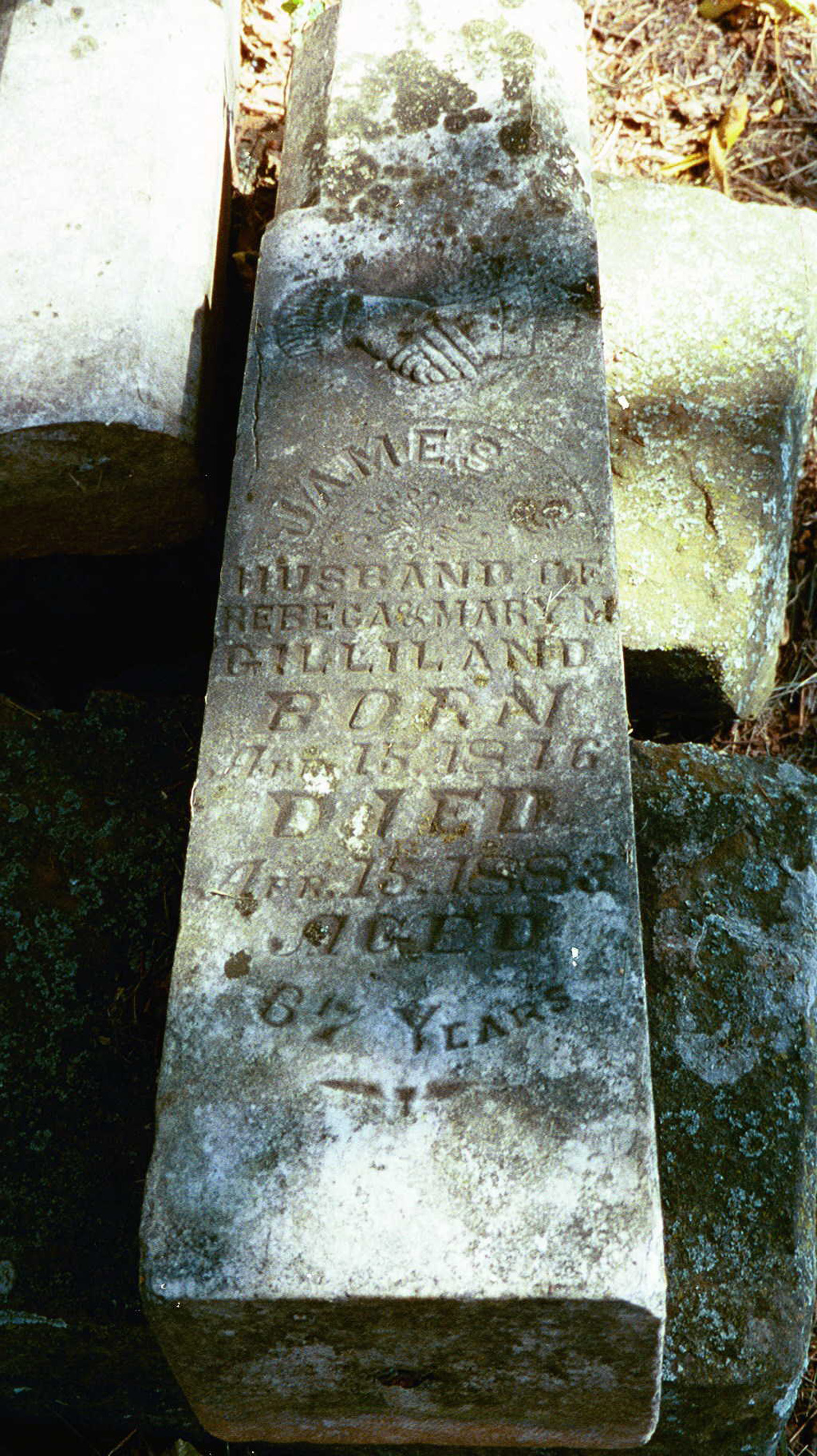
James Gilliland headstone, one of thirteen graves in the Gilliland family cemetery. James was the father of Cal and Jeff.
Three years later, in 1880, Jeff Gilliland remained at large at his home near West Fork. In 1882, a U. S. marshal out of Fort Smith brought a posse to arrest him. He fired on them, wounding two. Over the next two years, Gilliland evidently carried out a war of revenge against the posse members, who reported being shot at on random occasions. He never served time for the William Jones killing, nor did Newton Jones stand trial for killing Bud Gilliland.[4]
This has been one of the more fascinating stories I’ve uncovered in my research for a book I’ve been working on, Murder in the County. It contains 50 murder stories from the 1800s in Washington County. I won’t tell you what happens next to Newton Jones or Jeff Gilliland except to say the story takes a couple more intriguing twists and turns.
During these early years, as I mentioned earlier, West Fork the town did not exist where it’s now located. But the area was known as a peaceful and fruitful location. Local farms produced everything from apples to wheat. A main road south passed through the valley and stagecoaches traveled through Campbell Community north of West Fork and stopped at the home of John Karnes and later his son Daniel Karnes where travelers could have a meal, stay in overnight lodging, and fresh horses or mules teams could be hitched.
However, for particular travelers, another stop a few miles down at the Woolsey store offered a jot of whiskey. As noted by local historian Robert Winn,
It was not unusual for the stage to stop long enough [at Woolsey] that travelers imbibed enough to become tipsy and occasional excitement resulted in the form of fisticuffs or gun play.[5]
Fifty years after the first white people arrived in the west fork valley, the modern day location of West Fork began to formalize. In 1875 or ’76, the old water-mill plant at the head of the creek at Woolsey was moved north to what would become the town of West Fork. The new steam mill at West Fork provided reliable power for grinding grain, sawing lumber, and even operating a carding-machine which straightened and cleaned fibers for weaving into cloth. A spoke factory opened and the place attracted other industries including blacksmith shops.
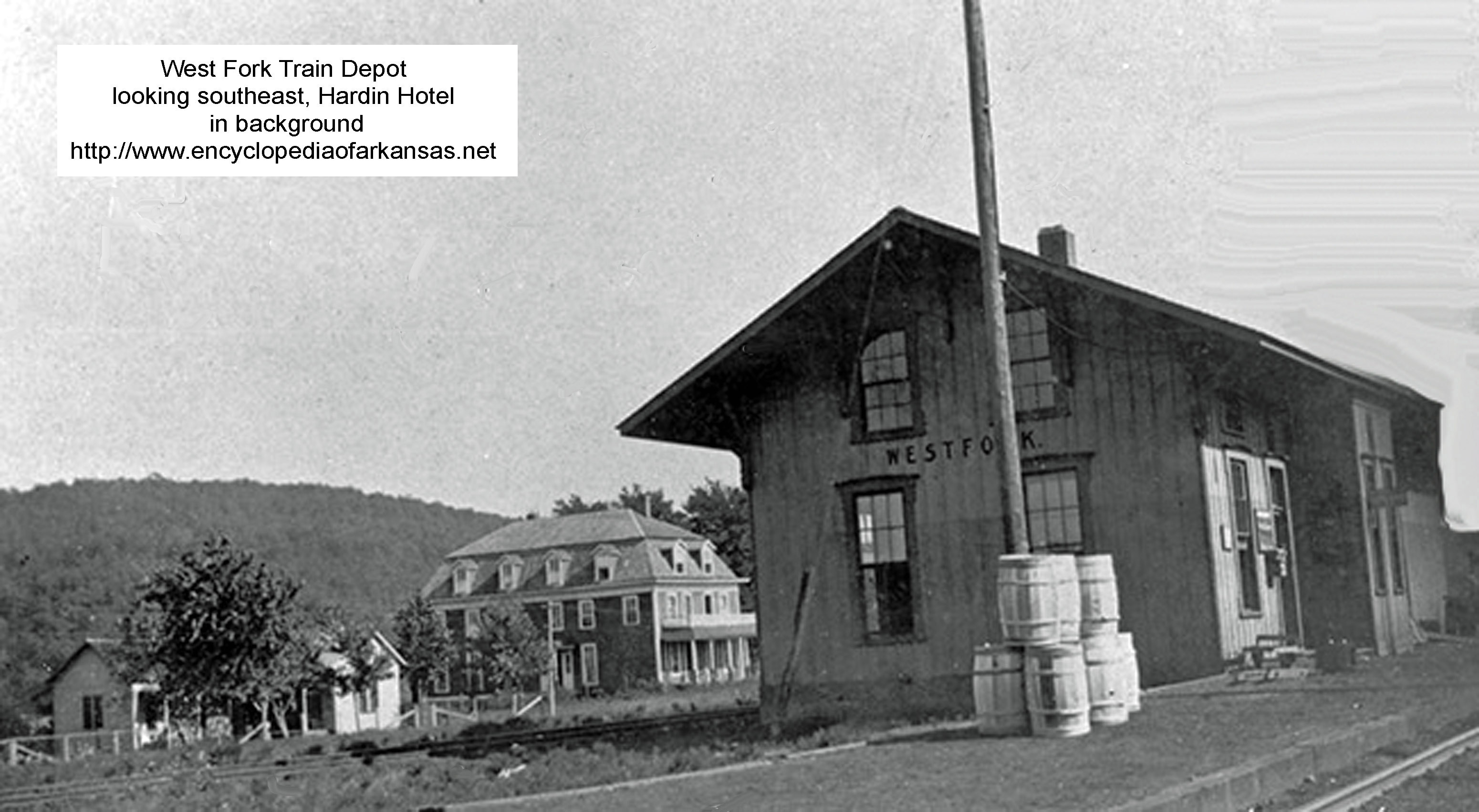
Looking southeast. The Hardin Hotel was built upon the arrival of the railroad at West Fork. The three-story structure included a large dining room where lodgers were fed family style on a huge round table. William Dunbar, who lived at the hotel as a child in the 1920s and 30s remembers an enormous cookstove in the adjacent kitchen. There was a carriage house and the carriage was dispatched to the train depot with each arrival, bringing visitors to the hotel. Robert Winn, in his book “Railroads of Northwest Arkansas,” said that “When drummers arrived at the West Fork station, they registered for lodging–50¢ to $1 per night, meals 25¢ …” There was no indoor plumbing, but according to Dunbar, the outhouse was somewhat luxurious with nice gabled roof, finished interior, and three ‘holes’ for mixed gender usage. But no heat. “You could freeze your bottom off in winter.” Dunbar stated the hotel was taken down in the 30s and the lumber used to build the house currently located on that corner (southeast corner of Main and Maple). The aged oak beams were so hard that when they were repurposed for the house, the carpenters had to use blocks of paraffin to ease the nails through the wood. The existing sidewalk along the property’s north side may date to hotel days.
In 1882, the St. Louis-San Francisco Railroad punched through this area headed south. A flood of newcomers followed, eager to make money off the harvest of virgin forest. This hard work involved teams of mules, men on either end of big crosscut saws, and plenty of hacking by ax to clear limbs off the main trunk. Then there was the matter of getting the logs down to the train depot. Many of those logging roads became the roads we drive today.
Things in the south county changed a lot then. Entrepreneurs of all stripes rushed into the area to make money. One example was a man named Erastus Pitkin. He bought out much of Woolsey’s land and with the formalizing of West Fork at its current location in 1885, the place at Woolsey became known as Pitkin. Pitkin partnered with another man to open a hardwood lumber operation at West Fork. They ordered ‘log wagons’ from the Springfield Wagon Company. These wagons were essential for moving cut logs down to the railroad and featured a specialized heavy-duty construction with independent axles.
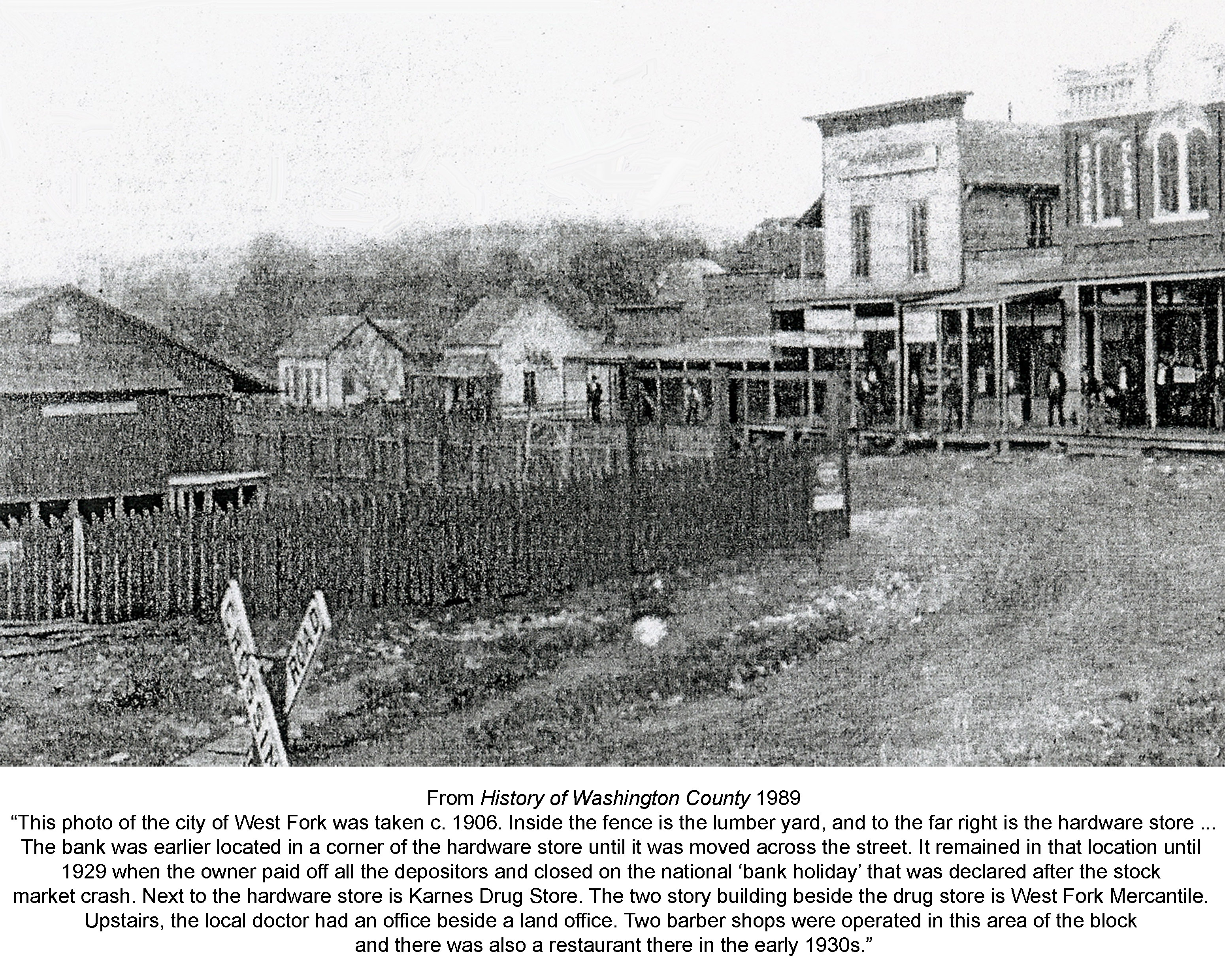
From 1906 Plat Book for Washington County. A few businesses have been identified and labeled.
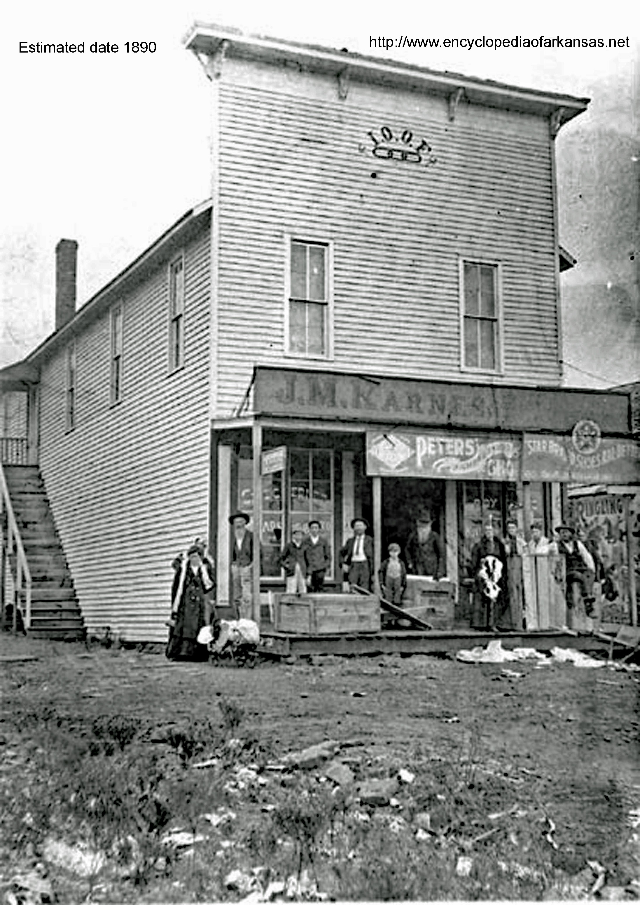
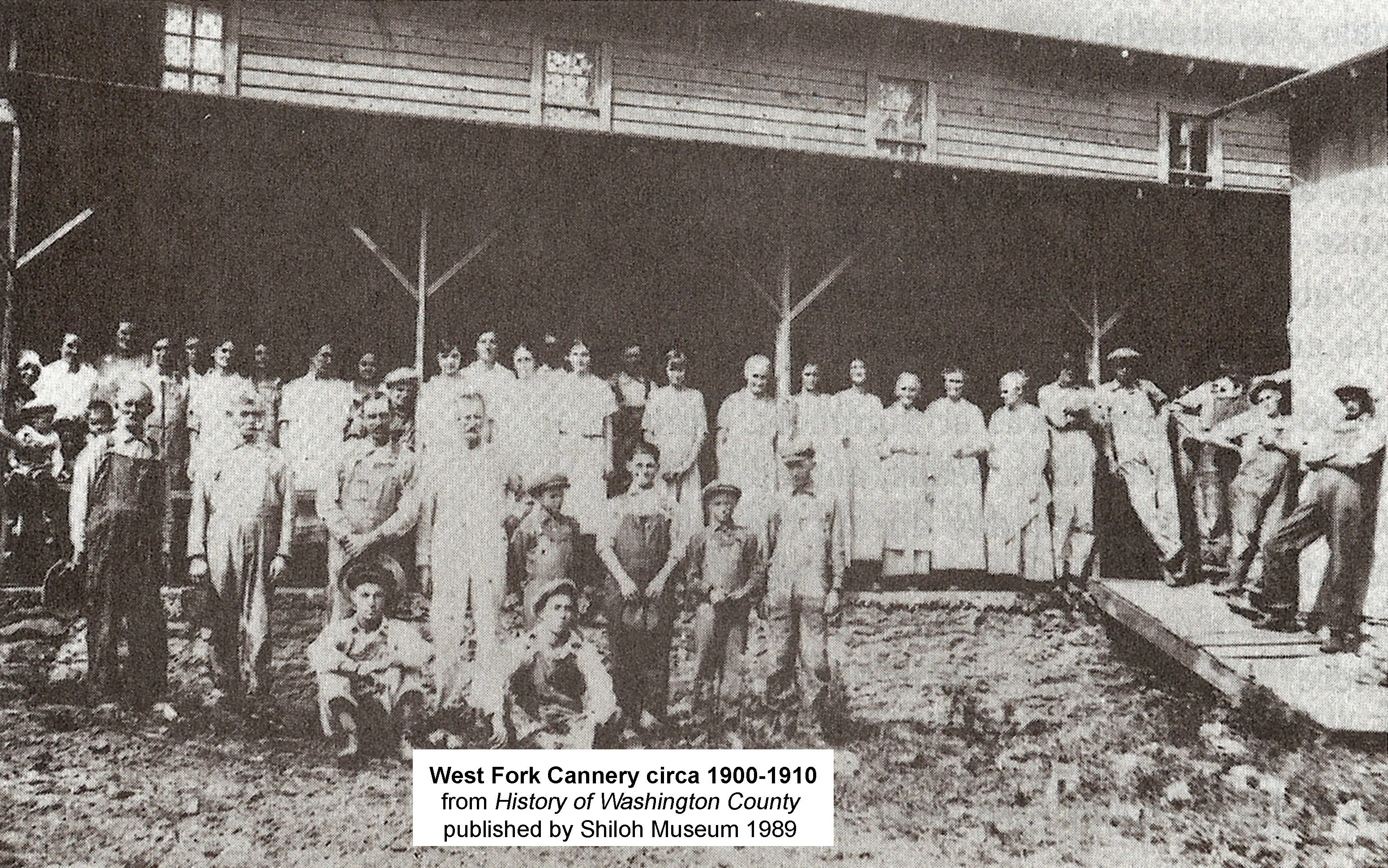
In May 1885, another early settler named Thomas McKnight finalized plans to incorporate the modern day town of West Fork. Since before the railroad’s completion, McKnight had been buying up land in the area that would become the town of West Fork. He platted town lots and sold to men eager to open for business. Within four years, the town included not only the thriving mill, but two general stores, a drug store, a grocery, a meat market, a hardware store, furniture store, the Hardin Hotel, and a food production company that employed 37 workers in canning tomatoes and drying local apples produced on farms up and down the valley.
Karnes Store
An amusing note – Robert Winn reported that the West Fork canning factory had an interesting side effect on the local population.
“Juice from the apples ran in shallow trenches from the building out into the warm sunshine. Peelings were also dumped near the factory; these also fermented. All livestock ran on open range and wandered about the factory. Cows, pigs, poultry, and any other livestock drank the juice and ate the peelings. Soon after the factory opened each fall, every cow, pig, and chicken that was permitted on the open range staggered home at night in a drunken condition.”[6]
During this boom period another local feud came to a boil. A man named Jim Graham brought up on charges of arson. Among those testifying against him at trial was Calvin Rutherford. Once Graham had served his two year sentence, he came back to West Fork with a serious grudge against Rutherford. In February 1892, the lid blew off.
Here’s the account published in the Fayetteville paper:
On Friday evening last, [Rutherford and Graham] got into a fight in Yoes’ store and when the smoke cleared away, Graham was found to be mortally wounded by a pistol ball that entered his body near the hip and ranged upward coming out on the opposite side near the collar bone.
Cal Rutherford and his brother Bob were both cut in several places, the latter not seriously. It is hard to get the exact facts in the case but we learn that the Rutherford boys were drinking and that Cal was taking in the town. Before the fight occurred, he rode into a store and smashed the store window and was pretty badly cut by the glass. He then rode his mule into Yoes’ store and as he was coming out, Jim Graham and a stranger whose name we did not learn went into the store.
When Rutherford saw Graham, he is said to have made some remark about whipping him and went back into the store when the fight commenced. Graham cut Cal four times and while he was doing so, Bob Rutherford came in. Graham then started to run upstairs and was shot by Bob. The latter was also cut but whether by Graham or someone else we have not learned.
Graham died Saturday afternoon and a warrant was sworn out before Squire Lusk of this city for the arrest of the Rutherfords charging them with murder. Constable Burkitt took charge of and was guarding them but on Sunday while he was at dinner, Bob Rutherford escaped and has not yet been apprehended.
Jacob Yoes Hardware store, scene of the Graham murder. Presently, this century-old building houses the West Fork Oprey.
A bit more info is found in the Little Rock paper’s article on the matter:
News has reached here of a bloody affray between the Rutherfords and Grahams, of West Fork, two families who have made themselves notorious as desperadoes … Cal Rutherford, Deputy United States Marshal of this District, was drunk and was running the town, and after riding his horse through two or three stores, and shooting at everything in sight, rode in the store owned by Jacob Yoes, United States Marshal Western District of Arkansas, and there found Jim Graham. He began cursing and abusing him and threatened to kill him. He then jumped from his horse and rushed at Graham, who drew his knife and stabbed Rutherford five times in the breast and bowels when Bob Rutherford intervened and Graham stabbed him twice. Bob Rutherford rushed for a pistol, securing one in the store, with which he did lively work, shooting Graham several times, only one shot taking effect which will prove fatal. A bystander, Mack Matthews, made an effort to quell the row and Bob Rutherford crushed his skull with a pistol. Cal Rutherford will probably die from the wounds and Bob may recover. The Sheriff and Constable took charge of the parties and have them under heavy guard.
Yee haw, boys!
So what happened to West Fork? Obviously, times changed. The big tree harvest and easy money from the crowds of timbermen came to an end. Once the tree is cut, it’s gone. Fruit crops and local canneries suffered from growing competition and new food purity laws. Farmers discovered that the soil was easily depleted and crops didn’t flourish. Also, south county water supplies couldn’t meet the growing demand.
West Fork prospered fairly well until 1919 when an entire block of downtown burned to the ground. The bank lasted until 1929 and closed with the stock market crash. As roads improved and more people made use of motor vehicles, travel became much easier and people began commuting to Fayetteville for jobs, taking even more money away from local businesses. It’s the story of thousands of small rural communities in our country.
(Adapted from a talk I gave May 6, 2017, sponsored by the Friends of West Fork Library and the Washington County Historical Society. Additional photographs will uploaded soon.)
Earliest known photograph of West Fork school, circa 1894. Far left is teacher and his assistant.
~~~
[1] After notice of my talk came out, I was contacted by a man who descended from Richard Dye. We chatted about the location of the school and church. He thought it was on the east side of the highway and a little south, roughly in the area where McKnight’s wrecker service is at this time, perhaps upslope south of the creek bottom. Another source confirms that “Dye’s Shed” was located just south of the business location. (We Call It Home by Harold G. Hutcheson and Bernice Karnes. Observer Press circa 1985.)
[2] “Early Days at West Fork,” Bernice Karnes. Flashback November 1956. 13-18. Fayetteville: Washington County Historical Society.